.
.
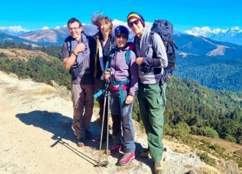
The Everest Three Passes trekking route is a perfect blend of thrill, challenge, and adventure with deep natural and cultural immersion in the pristine Himalayas. It is an ideal endeavor for trekking enthusiasts seeking remarkable experience in the foothills of the world’s highest peak, Mount Everest, in the Everest region. The Everest Base Camp Three Passes Trek is an exhilarating adventure due to its high-altitude mountain passes, diverse stunning landscapes, untouched nature, and up-close vistas of some of the enthralling Himalayas.
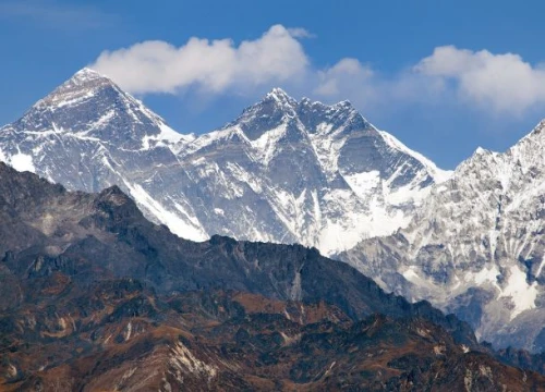
The Everest Three High Passes Trek passes through numerous Sherpa villages on the way. Along the trekking trails of this adventure, you will stop at places like Phakding, Namche Bazaar, Thame, Marlung, Gokyo, Lungden, Lobuche, etc, for accommodation. During the trek, you will navigate across varying landscapes like forests, hills, rivers, valleys, farmlands, waterfalls, religious heritages, pastures, meadows, glaciers, etc. You will cross the three formidable high Himalayan passes, Kongma La (5,535 meters), Cho La (5,420 meters), and Renjo La (5,360 meters). You will also reach the classical Everest Base Camp (5,364 meters). Additionally, you will reach the highest point during the entire trekking journey at Kalapatthar (5,643 meters). All these trails, landscapes, and elevations are prominently illustrated and marked on the Everest Three Passes Trek map.
The Everest Three Passes Trek map is handy for accessing the required information on the trekking routes and destinations. This map is vital to upgrading your trekking experiences by accurately pinpointing the geographical features of the trekking region, like hills, rivers, cultural landmarks, lakes, waterfalls, glaciers, mountains, etc. The Everest Three Passes Trek map outlines the trails that start from the Lukla in the lower foothills and ascend through varied Himalayan terrains to the high mountain passes and scenic viewpoints. So, get a deep look over the Everest Three Passes trek map to get insights into what the track actually looks like and find out the distances between two villages and the destination based on your chosen itinerary.
What is the Everest Three Passes Trek Map?

The Everest Three Passes Trek map is a visual representation of the details of the trekking trails and terrains in the Everest region through which the trek passes. On this map, you will find a distinctive set of symbols designed to provide details about the route. These symbols come in various shapes and colors, each representing specific features such as airports, national parks, primary trek routes, alternative paths, checkpoints, architectural sites, and so on. The contour lines on the map demonstrate elevation shifts throughout the journey. Additionally, the map also highlights side trips and notable spots along the trekking trails.
The Everest Three Passes Trek map helps you to identify prominent landmarks along the route. It facilitates you to find out whether the trail climbs a hill, crosses a river, or winds through dense forests. It also pinpoints elevations at every stop and lets you know how high you have reached. Using a compass on the map, you can precisely measure the distances from your current trekking location to each day's designated destination. This will help for an informed journey as well as smooth navigation of the wilderness routes during the Everest Three High Passes Trek.
Importance of Everest Three Passes Trek Map

The map counts as handy and useful during your remote high-altitude adventure of Everest Three Passes Trek. This wilderness trekking journey encounters and traverses you through the diverse mountainous trails and terrains, covering almost every part of the Khumbu region. You will venture deep into the backwood Everest region locations beside the well-trodden standard Everest Base Camp trekking route. So, consider carrying the Everest Three High Passes Trek map for efficient navigation of the backcountry trails during your thrilling and solitary adventure in the mountains.
The Everest Three High Passes Trek map will help you find out the directions, identify surrounding attractions, and find your way from one place to another. The map provides detailed information on location with elevation and distance data of each. It also offers extensive explanations about trekking trails, upcoming stops, villages, teahouses, heritages etc, along the route. This ensures a well-informed journey, allowing for easy navigation and deep immersion without missing any highlights during your remarkable adventure.
Before packing the Everest Three Passes Trek map in your backpack, you need to understand the appropriate way of reading maps and finding the correct routes. Going through the map thoroughly and learning about the symbols, colors, markings, grid lines, contour lines, scale, etc, will prepare you for the journey. You will understand the geographical features, plan the routes, and navigate unfamiliar terrains with precision. If you are a proficient map reader, you can decide where to trek next. Furthermore, with a careful analysis of the map, you can accurately calculate the elevation gain during a demanding climb, such as hiking to Kalapatthar, crossing three passes, etc.
Everest Three Passes Route, Distance, and Elevation Details
| Route | Distance | Elevation Evaluation |
| Lukla (2,800 meters) to Phakding (2,652 meters) | 8 kilometers | Elevation loss = 148 meters |
| Phakding to Namche (3,440 meters) | 10 kilometers | Elevation gain = 788 meters |
| Namche to Thame (3,800 meters) | 8 kilometers | Elevation gain = 360 meters |
| Thame to Marlung (4,210 meters) | 6 kilometers | Elevation gain = 410 meters |
| Marlung to Lungden (4,380 meters) | 6 kilometers | Elevation gain = 170 meters |
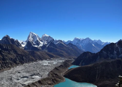
| Lungden to Gokyo (4,800 meters) via Renjo La (5,360 meters) | 7 kilometers | Elevation gain = 980 meters Elevation loss = 560 meters |
| Gokyo-Gokyo Ri (5,357 meters) - Thagnag (4,750 meters) | 8 kilometers | Elevation gain = 557 meters Elevation loss = 607 meters |
| Thagnag to Dzongla (4,830 meters) via Cho La (5,420 meters) | 7 kilometers | Elevation gain = 670 meters Elevation loss = 590 meters |
| Dzongla to Lobuche (4,940 meters) | 8 kilometers | Elevation gain = 110 meters |
| Lobuche to Everest Base Camp (5,364 meters) to Gorakshep | 9-10 kilometers | Elevation gain = 424 meters Elevation loss = 200 meters |
| Gorakshep (5,164 meters)-Kalapatthar (5,643 meters)- Lobuche | 8-9 kilometers | Elevation gain = 479 meters Elevation loss = 703 meters |
| Lobuche to Dingboche (4,410 meters) via Kongma La (5,535 meters) | 10 kilometers | Elevation gain = 595 meters Elevation loss = 1,125 meters |
| Dingboche to Kyanjinma (3,640 meters) | 15 kilometers | Elevation loss = 770 meters |
| Kyanjinma to Monjo (2,835 meters) | 13 kilometers | Elevation loss = 805 meters |
| Monjo to Lukla | 9 kilometers | Elevation loss = 35 meters |
Everest Three Passes Trek Itinerary - General Overview

As we go through the standard Everest Three Passes Trek map, our adventure will start from Lukla. We will get to Lukla with a picturesque 40-45 minutes of flight from the capital city, Kathmandu. Upon landing at Lukla airport, we will start on the trail and head towards Phakding. From Phakding, you will trek towards the vibrant Sherpa town of Namche Bazaar. At Namche Bazaar, we will be at above 3,000 meters altitude. So, we will take a day to rest and acclimatize in Namche Bazaar before heading further into the higher altitudes. Acclimatization is essential to adapt well to the low oxygen levels of rising elevations.
Then, after a day well spent resting, acclimatizing, and exploring Namche Bazaar, we will continue on the trek, heading towards Thame. This traditional Sherpa village is also the birthplace of Tenzing Norgay, who first ever climbed Mount Everest along with Sir Edmund Hillary. Walking past several religious landmarks like Monasteries, Chortens, Shrines, and Mani Walls, we will reach picturesque Marlung village. Proceeding further on the lush trekking trails, we will traverse several high-altitude landscapes to the Lungden village.
On day 9 of Everest Three Passes Trek, we will cross one of the challenging high Himalayan passes, Renjo La. This pass connects the Thame Valley to the Gokyo Valley. We will navigate this pass en route as we trek from Lungden to the Gokyo Lakes in the Gokyo Valley. On the next day, we will hike to Gokyo Ri viewpoint peak before a break of the day. We will enjoy the magnificent sunrise view and a sweeping panorama of the majestic Khumbu region Himalayas and glaciers from this stunning vantage point. After the breathtaking views from Gokyo Ri, we will trek down to Thagnag for an overnight stay.
Following the classical Everest Three High Passes Trek map, we will cross another high mountain pass of Cho La during the trek from Thagnag to Dzongla. The next day, we will trek from Dzongla to Lobuche, passing through several cultural villages dotted with terraced farmlands and scenic forested trails. Day 13 is a big day in the Everest Three Passes trekking adventure. Today, we will depart from Lobuche early in the morning and reach the iconic base camp of the world’s tallest mountain, Everest, via the last settlement in the Everest region, Gorakhsep. We will again return to Gorakshep to stay for a night.
Scaling the Kalapatthar for its breathtaking sunrise and majestic panorama of the Himalayas is an essential highlight of any adventure in the Khumbu region. So, for the same reason, we will ascend to this fantastic viewpoint before dawn. Following this awe-inspiring experience, we'll trek back to Lobuche. Day 15 is another exciting day as we will overcome the final Himalayan pass of this adventure. We will head toward Dingboche from Lobuche, traversing the Kongma La Pass.
Wrapping up this unforgettable Himalayan expedition, we will gradually descend through Kyanjinma, Monjo, and Namche Bazaar to where our adventure began (Lukla). Finally, on day 19, our exhilarating trek of Everest Three Passes ends with a short early morning return flight from Lukla to Kathmandu.
Everest Three Passes Trek - Difficulty

Distance, Duration, and Tough Trails
The Everest Three Passes Trek is a challenging and rewarding adventure, where you have to cover a total distance of around 130 to 140 kilometers round trip. The trek is usually completed in about 18 to 22 days. You will have to walk for approximately 7-8 kilometers on average during each trekking day to complete the total distance of the journey. The trails are physically demanding to navigate, which involve steep climbs, long descends, and some icy and rocky slopes. In order to immerse in the untouched beauty presented by the journey, you will have to pass over through its strenuous routes with long and intense trekking.
The remote exploration of this iconic Himalayan region via off-the-beaten trails can be draining and stressful to first-time trekkers. The trails are not straightforward and smoothgoing. Navigation of several uphill and downhill routes, crossing high mountain passes, scaling to the highest viewpoint of Kalapatthar, and reaching the astounding height of Everest Base Camp requires excessive physical exertion and endurance. Consecutive walking over uneven and rugged mountainous trails can cause physical as well as mental fatigue.
While the previous trekking experience is not compulsorily required, having one is beneficial in tackling the tricky trails and terrains. Plus, a considerable level of physical fitness and strong mental preparation, with courage, determination, resilience, and positive thinking, are essential to sustain the lengthy and challenging endeavor.
High Altitude and Altitude Sickness
The high altitude nature of the journey and the risk of altitude sickness is another concerning factor in the Everest Three Passes Trek. While the chance of altitude sickness increases after crossing the elevation of 2,500 meters, this alpine adventure will introduce you to significant altitude points. The major elevations you will reach during the Journey are Gokyo Ri at 5,357 meters), Everest Base Camp at 5,364 meters, Kalapatthar at 5,643 meters, and Gorakshep at 5,164 meters. Other than this, you will cross all three high passes, exceeding over 5,300 meters. Additionally, you will be staying above 4,000 meters in height during most part of the trek. So, there is a high risk of being affected by altitude sickness while on this adventurous undertaking in the mountains.
To avoid the possibility of altitude sickness, you need to maintain good hydration, eat healthy foods, stay away from smoking and alcohol consumption, pace slowly, and acclimatize properly. If you feel discomfort from altitude symptoms such as dizziness, headache, fatigue, nausea, vomiting, sleeplessness, breathlessness, etc., descend to lower elevations and stay there until your body is fully recovered to head into further elevation points.
Remoteness and Limited Facilities
The remoteness of the region also adds to the difficulty of the Everest Three Passes Trek.
The trekking journey takes place in secluded Himalayan areas, which are not adequately inhabited by the locals. The distance between two villages or teahouses is relatively far from each other. During the teahouse stay also, you need to be accustomed to simple living styles as you will only get basic accommodations and amenities. Everything from living rooms to toilets, bathrooms, and dining halls is available on a shared basis at teahouses. While the hot shower and WiFi facilities are provided by most of the lower altitude teahouses, you will have to pay additional costs for using the services. Since the facilities and amenities are limited, you need to be self-sufficient to maintain a level of comfort and well-being during this remote, high-altitude mountain journey.
Unpredictable Weather Conditions
The weather in the high-altitude region is unpredictable and quickly changeable. The temperature here is usually colder and also fluctuates a lot. In a few minutes, a good sunny day can change into gloomy with dark rain clouds looming in the sky. Generally, high winds, blizzards, fog, heavy snowfall, etc can challenge your high-altitude climbs during the journey. So, being flexible with the itineraries is essential in case of interruptions caused by bad weather. Plus, staying updated with the recent weather forecast will help you make informed decisions accordingly. It is also important to pack appropriate gear and clothes for efficient navigation and to stay warm and comfortable in ever-changing alpine weather conditions.
Gain Insights On:
Permits to Proceed Through Everest Three Passes Trek Map

Sagarmatha National Park Entry Permit
The Everest Three Passes Trek map leads you through the protected area of the Sagarmatha National Park. It is a UNESCO-listed natural World Heritage Site with a diverse range of flora and fauna. To access this conserved area for trekking purposes, you need to acquire a Sagarmatha National Park entry permit. The cost of this permit is NPR 3,000, which goes for the conservation efforts of its fragile ecosystem. The generated revenue through permit fees will also help to promote sustainable tourism in the region while preserving nature and heritage for generations to come.
Khumbu Pasang Lhamu Rural Municipality Entry Permit
While following the Everest Three Passes Trek map, you will have to traverse the controlled area in the Everest Himalayan region to continue and complete the adventure. To access the regions that fall under the Khumbu Pasang Lhamu Rural Municipality all areas of Ward no 5, you need to get a special local area permit. The cost of a Khumbu Pasang Lhamu Rural Municipality Entry Permit is USD 20 for the first four weeks and USD 25 beyond four weeks.
The collected permit fees contribute to the local development projects, infrastructure management, and conservation initiatives in the region. The generated revenue helps to uplift the lifestyle of the local communities and provide enhanced facilities for visitors who venture into this region. Permit regulations are also essential for responsible trekking practices and reducing the environmental impact of tourism by limiting overcrowding in fragile areas.